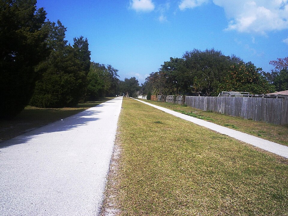
Forty-seven miles of paved, car-free railroad corridor running the length of Pinellas County — and one of a handful of trails in the country in the Rail-Trail Hall of Fame. Here’s where to park, which section to ride, what you’ll see, and where to eat when you get there.
Why We Love This Trail
Most of Florida is flat, hot, and built for cars. The Pinellas Trail is the exception that an entire cycling culture has grown up around.
It follows the beds of two abandoned railroads — the old Orange Belt Railway corridor from Tarpon Springs down to Clearwater, and the Tampa & Gulf Coast line from Clearwater south to St. Petersburg. When CSX abandoned 34 miles of track in the 1980s, the county bought the right-of-way and started paving. The first five miles opened in December 1990, connecting Taylor Park in Largo to Seminole City Park in Seminole. Thirty-five years later it runs the length of the county.
What makes it special isn’t wilderness — this is an urban trail and it never pretends otherwise. What makes it special is that you can ride for hours without a car beside you, through a dozen towns, past parks and lakes and downtown squares, and stop for coffee or beer or lunch whenever you feel like it. It’s a rail-trail that actually goes places people want to go.
At a Glance
| 📏 Length | 47 miles (Tarpon Springs to St. Petersburg) |
| 🛣️ Surface | Paved asphalt, 12–15 feet wide |
| ♿ Accessibility | ADA-compliant |
| ⛰️ Elevation | Essentially flat |
| 💵 Cost | Free |
| 🕐 Hours | Dawn to dusk |
| 🚻 Facilities | Restrooms, water, benches at park trailheads |
| 🏕️ Camping | Not permitted on the trail |
| 🏆 Recognition | Rail-Trail Hall of Fame, inducted 2007 |
| 📞 Managed By | Pinellas County Parks — (727) 582-2100 |
Trail Map
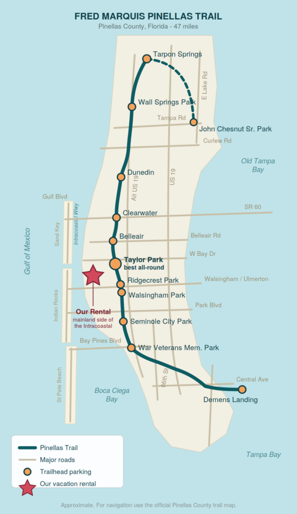
Note the geography: our rental sits on the mainland shore of the Intracoastal Waterway, not out on the barrier island. That means you reach the beach by crossing a causeway west, and the trail by driving a few miles east.
Where to Park: The Best Trailheads
On a linear trail, where you start determines what kind of day you get. Here are the trailheads worth knowing.
🥇 Taylor Park (John S. Taylor Park) — Our Top Pick
1100 8th Ave SW, Largo — around mile 18
If you only remember one trailhead, make it this one. It’s 156 acres wrapped around a 53-acre freshwater lake, with extensive parking, restrooms, picnic areas, playgrounds, playing fields, and a boat ramp. Riders consistently rate it the best place on the trail to start — full facilities, room to spare, and the trail runs right along it.
It’s also where the trail began: this is one end of the original five-mile segment that opened in December 1990. And its position near the middle means a good ride in either direction.
🥈 Walsingham Park — Closest to Us
12615 102nd Ave N, Largo — around mile 15
A large county park with parking and restrooms sitting right on the trail. Straight shot east from the rental on Walsingham Road, which makes it the easiest to reach. Good launch point for riding south toward Seminole.
🥉 Ridgecrest Park
12000 Ulmerton Rd, Largo — around mile 17
Parking and restrooms at the northeast corner of Ulmerton and the trail. Convenient, though Ulmerton is a busy road — be deliberate getting in and out.
Belleair Trailhead
1725 Indian Rocks Rd S, Belleair — around mile 20.6
Parking, restrooms, trail access. Handy if you want to head north toward Clearwater without driving as far.
Seminole City Park
7464 Ridge Rd, Seminole — around mile 13.4
Parking, restrooms, picnic areas, a playground, and a small local history museum run by volunteers. The southern end of the original 1990 segment.
Downtown Clearwater
645 Pierce St, Clearwater — around mile 22
Puts you in the urban middle of the trail and connects toward the Memorial Causeway if you want to ride out to the beach.
Dunedin — Best Destination
Main Street parking lot, 330 Douglas Ave, or Josiah Cephus Weaver Park, 1258 Bayshore Blvd — around mile 25.7
The most popular stretch of the trail, and the one place where parking genuinely fills up. Arrive before 10am on a weekend, or start at Weaver Park north of downtown.
Wall Springs Park, Palm Harbor
Desoto Blvd, Palm Harbor — around mile 33. A historic spring, boardwalks over the bayou, and an observation tower with a genuinely good Gulf view. The prettiest section of the whole trail.
John Chesnut Sr. Park
2200 E Lake Rd S, Palm Harbor — 255 acres on Lake Tarpon with nature trails and a lookout tower. On the East Lake spur, and the junction where the Duke Energy Trail meets the Pinellas Trail.
Southern End
Demens Landing Park, St. Petersburg (mile 0, downtown waterfront), plus Azalea Park (72nd St N) and War Veterans Memorial Park (9600 Bay Pines Blvd).
Mile Markers
| Mile 0 | Demens Landing Park, St. Petersburg |
| 7.5 | Azalea Park, St. Petersburg |
| 10.2 | Cross Bayou, Pinellas Park |
| 13.4 | Seminole City Park |
| 15.2 | 102nd Ave N (Walsingham Park), Seminole |
| 17.2 | Ulmerton Rd (Ridgecrest), Largo |
| 18.2 | Taylor Park, Largo |
| 18.7 | West Bay Drive, Largo |
| 20.6 | Belleview Blvd, Belleair |
| 22.2 | Cleveland Street, Clearwater |
| 25.7 | Main Street, Dunedin |
| 28.2 | Curlew Rd / Honeymoon Island Causeway |
| 29.8 | Tampa Rd, Palm Harbor |
| 33.0 | Wall Springs Park, Palm Harbor |
| 35.4 | Tarpon Ave, Tarpon Springs |
Four Rides We’d Recommend
🍺 The Dunedin Lunch Run — ~15 miles round trip
Start: Taylor Park, Largo | Ride: north to downtown Dunedin and back | Allow: most of a day if you linger
This is the classic, and if you do only one ride while you’re here, do this one.
What you’ll see: Leaving Taylor Park you’re immediately in the old rail corridor, running behind Largo’s neighborhoods rather than beside its roads. Around mile 20 you pass through Belleair, where the trail runs briefly along the road before ducking back into the corridor. Then Clearwater, which is more urban than you expect but well buffered with greenery — you’ll pass office buildings, cross a handful of streets, and get a look at the Cleveland Street district. North of Clearwater the character changes: this is where the trail finally picks up a real green buffer, with tree cover, quieter crossings, and glimpses of water to the west. You’ll pass the Blue Jays’ spring training complex before rolling into Dunedin.
Where the trail drops you: Straight into downtown Dunedin, one of the most walkable small downtowns on the Gulf Coast, with bike racks everywhere.
Lunch:
- Cafe Alfresco, 344 Main St — the trailside standby, right where the trail crosses Main. Glassed-in patio, grouper nuggets and crab cakes, casual enough for cycling clothes.
- Crown and Bull, 319 Main St — a big outdoor patio under string lights, brunch through dinner, often live music. Popular, so expect a wait at peak times.
- Clase Azul Bar & Grill, 1056 Main St — Mexican, generous portions, consistently well reviewed.
- The Living Room on Main, 487 Main St — a step up in price; gastropub food with a Japanese-fusion streak.
Coffee: Dunedin Coffee Company & Bakery, 730 Broadway, or Tükrō Coffee Shop, 472 Wood St — the latter tucked into a little house on a quiet street with a shaded front porch.
Beer, if you’re not riding far after: Dunedin has an outsized brewery scene for its size. Cueni Brewing Co. (945 Huntley Ave) sits essentially on the trail with a shaded patio. Dunedin Brewery (937 Douglas Ave) is one of Florida’s original microbreweries, with food and weekend live music. 7venth Sun (1012 Broadway) is the one locals send you to for sours. Woodwright Brewing (985 Douglas Ave) has a barn-style space and a food truck, but check hours — it’s closed early in the week.
Ride responsibly: it’s a fifteen-mile round trip, and the ride home is on a shared trail with pedestrians and kids on it.
🌳 The Family Loop — ~5–6 miles round trip
Start: Taylor Park | Ride: south to Ridgecrest and back | Allow: 1–2 hours
Short, flat, close to home, and reversible the moment somebody’s had enough.
What you’ll see: Quiet residential corridor, tree cover in patches, a couple of signalized crossings that are good practice for kids learning trail etiquette. The real draw is the bookends: Taylor Park itself has the 53-acre lake, a playground, ballfields, and a boat ramp, so you can turn a short ride into a whole afternoon without driving anywhere else.
Worth adding: The Florida Botanical Gardens and Heritage Village sit close to this stretch in Largo — 180-plus acres of gardens and a living-history museum of relocated pioneer buildings. Both free. Easy to combine with a morning ride.
Food nearby: Golden Bear Restaurant, 12540 Starkey Rd — opens at 6am, classic mom-and-pop breakfast, worth arriving hungry. For lunch, Roosterfish Grill at 776 Missouri Ave N is casual seafood close to the corridor, and Turkish Mediterranean Cuisine at 1921 W Bay Dr is a genuine local favorite if you want something different.
🏛️ The Tarpon Springs Run — ~19 miles round trip
Start: Wall Springs Park, Palm Harbor | Ride: north to Tarpon Springs and back | Allow: a full day
The prettiest riding on the trail, ending somewhere that feels nothing like the rest of Florida.
What you’ll see: Wall Springs Park is worth twenty minutes before you even start — a historic spring feeding Boggy Bayou, boardwalks through coastal hammock, and an observation tower with a wide Gulf panorama. Heading north the corridor is green and shaded, passing Pop Stansell Park and the quiet township of Palm Harbor. At Bayshore Boulevard there’s a pedestrian bridge around mile 29 with more Gulf scenery. Then the trail runs into Tarpon Springs’ historic business district and continues under US 19.
The destination: The Sponge Docks on Dodecanese Boulevard — the center of the Greek-American community that built this town on the sponge industry, and still the best Greek food in the state.
Lunch:
- The Limani, 776 Dodecanese Blvd — a cash-only walk-up window with covered waterfront seating. Gyros and feta fries that people compare favorably to Greece. There’s an ATM out front. Our pick.
- Rusty Bellies Waterfront Grill, 937 Dodecanese Blvd — big waterfront deck, boats coming and going, live music. Expect a wait at peak hours.
- Dimitri’s on the Water, 690 Dodecanese Blvd — covered deck on the harbor, traditional Greek. Closed Wednesdays.
Note: this trailhead is about an hour’s drive north of the rental. Best treated as a day trip rather than a quick outing.
🚴 The Full Length — ~37 miles one way
Route: Tarpon Springs to St. Petersburg | Allow: 4–6 hours riding, plus logistics
Doable in a day for a fit rider. The trail changes character completely as you go: green and shaded in the north, urban and busy through Clearwater and Largo, then increasingly built-up as you approach St. Petersburg, before the final stretch curves east to the downtown waterfront at Demens Landing.
The logistics: You need a shuttle or a plan. The standard solution is that PSTA buses carry bikes — ride one direction, bus back. Check the route and schedule before you commit; you don’t want to be figuring that out at mile 35.
Along the way: Downtown Clearwater around mile 22 is a natural halfway stop — Clear Sky on Cleveland (418 Cleveland St) opens at 8am and is a block off the trail, and Cleveland Street Market (1011 Cleveland St) is a food hall with several options under one roof, which is useful when a group can’t agree.
Know Before You Go
🚦 Road Crossings Are the Real Hazard
This is an urban trail with many at-grade street crossings. Trail users may have the right-of-way where traffic is light, but that does not hold where the trail crosses a major artery like State Road 60. Slow down, look, and assume a turning driver hasn’t seen you.
🌡️ Ride Early in Summer
Long stretches have no shade, and between May and September the middle of the day is unpleasant and occasionally dangerous. Dawn rides are a different world. Carry more water than you think you need — there are fountains at park trailheads, but don’t stake a ride on any one of them working.
🏙️ Some Sections Are More Urban Than Others
Being straightforward: the trail passes through some neighborhoods in St. Petersburg, Clearwater, and Tarpon Springs where users are advised to be cautious. That shouldn’t stop you from riding — but ride with a companion in the emptier stretches and skip riding alone after dark. From Largo north, the corridor gets greener and better buffered.
🚌 Bikes Ride the Bus
PSTA buses and the Suncoast Beach Trolley both carry bicycles, which turns a one-way ride into a practical plan.
📖 Get the Guide
Pinellas County publishes a free pocket-size Guide to the Pinellas Trail, a flip-chart map showing rest stops, restaurants, bike shops, and parks along the route. Available at area libraries, the county courthouse information desk, and online.
Connecting Trails
- Duke Energy Trail — joins at John Chesnut Sr. Park, 12 miles down the east side of the county
- Memorial Causeway Trail — links downtown Clearwater to Clearwater Beach
- Ream Wilson Clearwater Trail — the east–west connector toward Safety Harbor
- Honeymoon Island Causeway spur — at Curlew Road, around mile 28
- Florida Coast to Coast Trail — the Pinellas Trail is the westernmost segment of a route running more than 200 miles across the state to Titusville
👉 Back to our full biking guide
Getting There from Our Vacation Rental
From: 1731 Clearwater Harbor Dr, Largo, FL
To Walsingham Park (closest): East on Walsingham Road, then to 102nd Ave N. Roughly 5 miles.
To Taylor Park (best facilities): East on Walsingham Road, north on Seminole Blvd, east to 8th Ave SW. Roughly 6–7 miles.
📱 GPS directions to Taylor Park
Contact Information
Pinellas County Parks & Conservation Resources
Phone: (727) 582-2100
Friends of the Pinellas Trail
Volunteer group publishing maps, FAQs, and trail updates
Staying with us and planning to ride? Ask us — we can point you to the right trailhead for your group and help sort out bike rental delivery before you arrive.