Twelve miles down the quiet east side of Pinellas County, mostly under power lines. It isn’t the prettiest ride on this coast and we won’t pretend otherwise — but it’s the piece that makes everything else connect, and the park at its northern end is worth the drive on its own.
Let’s Be Honest About This One
Every trail guide on the internet says the same thing about the Duke Energy Trail, and they’re all right: it runs under high-tension power lines for most of its length, there’s essentially no shade, and the scenery is functional rather than beautiful. Riders describe it as an efficient way to get somewhere better rather than a destination in itself.
So why does it have its own page here?
Because “an efficient, safe, car-free route across a densely developed county” is a genuinely valuable thing. This is the trail that carries you from the Pinellas Trail over to the Ream Wilson Trail and the Courtney Campbell Causeway. It’s the eastern leg of the 75-mile Pinellas Trail Loop. It has a pedestrian overpass of US 19, which anyone who has tried to cross that road will tell you is worth a great deal. And it’s wide, flat, straight, and well surfaced — which makes it excellent for fitness riding, where scenery matters less than being able to hold a pace without stopping every quarter mile.
It also has one genuinely lovely trailhead. More on that below.
At a Glance
| 📏 Length | About 12 miles currently open |
| 📍 Endpoints | John Chesnut Sr. Park (Palm Harbor) to Belleair Rd (Clearwater) |
| 🛣️ Surface | Paved asphalt, about 15 feet wide (narrower in places) |
| ⛰️ Difficulty | Flat and straight |
| 🌳 Shade | Very little |
| 🚻 Facilities | Good — restrooms at several points |
| 🔗 Connects | Pinellas Trail, Ream Wilson Trail, Druid Road Trail |
| 💵 Cost | Free |
| 🚗 From Our Rental | ~9 miles to the south end, ~20 to the north |
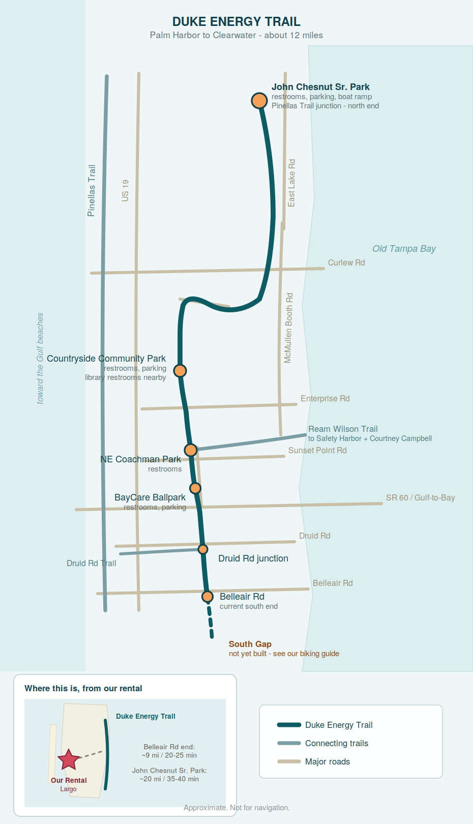
Trail Map
The Reason to Go: John Chesnut Sr. Park
If you ride only one part of this trail, start at the north end — because the trailhead is a 255-acre park on Lake Tarpon that would be worth visiting even if the trail didn’t exist.
There are 2.7 miles of nature trails in two loops, running on boardwalks through floodplain forest and cypress swamp along a genuinely wild stretch of shoreline. There’s an observation tower with views over Lake Tarpon, a boat ramp for paddling, a dog park, playgrounds, playing fields, picnic pavilions, and restrooms. It’s family-friendly and dog-friendly, and it’s free.
It’s also the junction where the Pinellas Trail meets the Duke Energy Trail, so it’s the natural hinge point for anyone piecing together a longer loop.
2200 E Lake Rd S, Palm Harbor
The Route
Riding north to south:
- John Chesnut Sr. Park — the trail runs alongside East Lake Road, separated from traffic by a wide median, with some road crossings.
- To McMullen Booth Road at Seagull Drive, crossing Brooker Creek and passing several residential developments.
- South along McMullen Booth to Tampa Blvd, crossing the Tarpon Outfall Canal bridge.
- Onto the service road and over to Countryside Blvd, which the trail follows for about a mile to Meadow Wood Drive. Several residential crossings here, plus one big one at Curlew Road — use the signals.
- Into the power line corridor a couple of tenths of a mile down Meadow Wood. This is the character of the trail from here south.
- Past Countryside Community Park and the Clearwater East Community Library on the St. Petersburg College campus — both with restrooms.
- Along the north edge of Northeast Coachman Park, where the trail briefly overlaps the Ream Wilson Clearwater Trail. This is your turn-off for Safety Harbor and the Courtney Campbell Causeway.
- Down Old Coachman Road for about a mile, past BayCare Ballpark, then across Gulf-to-Bay Boulevard, after which the trail moves away from roads.
- Across Druid Road, where the Druid Road Trail joins.
- South along the power lines to Belleair Road, the current end of the line.
Where to Park
🥇 John Chesnut Sr. Park — Best Trailhead
2200 E Lake Rd S, Palm Harbor. Parking, restrooms, and everything described above. Furthest from us, best experience.
🥈 Countryside Community Park
2640 Sabal Springs Dr, Clearwater. Parking and restrooms, roughly mid-trail. Good starting point if you want to ride the corridor in either direction.
🥉 BayCare Ballpark
601 N Old Coachman Rd, Clearwater. Parking and restrooms. Check the schedule — this is the Phillies’ spring training home, and on a game day it is not the place to leave your car.
Northeast Coachman Park
1120 Old Coachman Rd, Clearwater. Restrooms, and the junction with the Ream Wilson Trail.
Three Ways to Use It
🌲 The Lake Tarpon Morning — as long as you like
Park at John Chesnut, walk the boardwalk loops first, then ride south on the trail as far as you feel like before turning back. The nature trails and the observation tower are the point; the ride is the bonus. Best done early, when the wildlife is out.
💨 The Fitness Run — up to 24 miles round trip
This is what the corridor is genuinely good for. Long, flat, straight, few interruptions once you’re south of Curlew Road, and a wide surface. If you’re training rather than sightseeing, the Duke Energy Trail will let you hold a pace in a way the busier, prettier trails won’t.
🔗 The Loop Connector — a component, not a destination
Ride the Pinellas Trail north to John Chesnut, pick up the Duke Energy Trail south, then cut east on the Ream Wilson to Safety Harbor or the Courtney Campbell Causeway. This is how you build a genuinely long day out of the county’s trail network, and the Duke Energy Trail is the piece that makes it possible.
Know Before You Go
☀️ Sun Protection Is Not Optional
A power line corridor has no trees in it by design. There is nowhere to hide from the sun on most of this trail. Ride at dawn in summer, and carry water — the restroom stops listed above are your refill points, and they’re spaced miles apart.
🚦 The North End Has the Crossings
Between John Chesnut and the power line corridor the trail runs alongside roads with a number of residential crossings and one major one at Curlew Road. South of there it settles down considerably.
🏟️ Check the Ballpark Schedule
The trail runs right past BayCare Ballpark. During spring training the traffic and parking situation around Old Coachman Road changes completely.
🧭 It’s a Corridor, Not a Loop
Out-and-back unless you’re linking it to other trails. Plan your turnaround around the restroom stops rather than the mileage.
The South Gap
The trail currently ends at Belleair Road. Below that is the unfinished section of the Pinellas Trail Loop — the “South Gap” — running roughly twelve miles from Haines Bayshore Road down to the North Bay Trail in St. Petersburg. Parts are built, including an underpass at Ulmerton Road and a stretch using the existing Roosevelt Blvd trail, but the rest is phased out over the next several years.
When it’s done, the Duke Energy Trail stops being a spur and becomes the eastern half of a genuine 75-mile circuit.
👉 More on the loop in our biking guide
Connecting Trails
- Pinellas Trail — at John Chesnut Sr. Park, the northern junction
- Ream Wilson Clearwater Trail — briefly overlaps at Northeast Coachman Park; your route east
- Druid Road Trail — joins at Druid Road
- Courtney Campbell Causeway Trail — reachable via the Ream Wilson and Bayshore trails
👉 Our Pinellas Trail guide | Our Courtney Campbell guide | Back to our biking guide
Getting There from Our Vacation Rental
From: 1731 Clearwater Harbor Dr, Largo, FL
To the Belleair Road end: roughly 9 miles, 20–25 minutes. Closest access, least interesting stretch.
To John Chesnut Sr. Park: roughly 20 miles, 35–40 minutes. Longer drive, far better day.
📱 GPS directions to John Chesnut Sr. Park
Our honest advice: if you have one morning, ride the Pinellas Trail instead. If you have a week and you like riding, this one earns its place — and John Chesnut Sr. Park is worth the trip on any morning at all.