Four and a half shaded miles linking a string of Clearwater parks to the waterfront in Safety Harbor — and the hinge that connects every other trail in the county to every other one. Short, easy, and it ends in the nicest small downtown on this side of the bay.
First, About That Mileage
You’ll see the Ream Wilson Trail described as 13 miles in some places and 4 miles in others. Both are right, and the difference is worth understanding before you plan a ride.
The signed, built trail is about 4.4 miles, running from Coachman Ridge Park in Clearwater east to Veterans Memorial Lane in Safety Harbor. That’s what you’ll actually ride if you follow the Ream Wilson signs end to end.
The 13-mile figure refers to the Clearwater East–West Trail corridor — a long-term plan to link the Gulf of Mexico at Clearwater Beach to Tampa Bay at Safety Harbor. It’s a corridor under development, and it uses other trails (the Memorial Causeway, the Druid Road Trail, the Duke Energy Trail) to fill the gaps. Useful concept, but you can’t ride a continuous signed 13-mile Ream Wilson today.
So: plan around 4.4 miles each way, and add connectors if you want more.
Why We Like It
This is the friendly one. It’s short, it’s flat, it’s mostly shaded — which after the Duke Energy corridor and the causeway trails feels like a genuine luxury — and it strings together half a dozen parks in four miles. There’s a wetlands boardwalk, a kayak launch, a disc golf course, playgrounds, and fishing access, all hanging off one path.
And it’s the county’s most useful junction. The Duke Energy Trail crosses it. The Bayshore Trail branches off it toward the Courtney Campbell Causeway. The Safety Harbor Bike Trail picks up where it ends. If you’re building a long day out of Pinellas County’s trail network, you almost certainly pass through here.
The payoff at the east end is downtown Safety Harbor, which is small, walkable, and full of good independent restaurants.
At a Glance
| 📏 Length | About 4.4 miles each way (signed trail) |
| 📍 Endpoints | Coachman Ridge Park, Clearwater ↔ Veterans Memorial Ln, Safety Harbor |
| 🛣️ Surface | Paved asphalt and concrete |
| ⛰️ Difficulty | Easy, with gentle rolling on the western end |
| 🌳 Shade | Good — the best-shaded trail in our guide |
| 🚻 Facilities | Drinking fountains, restrooms, and bike repair stations |
| 🐕 Dogs | Welcome on leash |
| 💵 Cost | Free — no permits or entry fees |
| 🚗 From Our Rental | ~13 miles to the west trailhead |
Trail Map
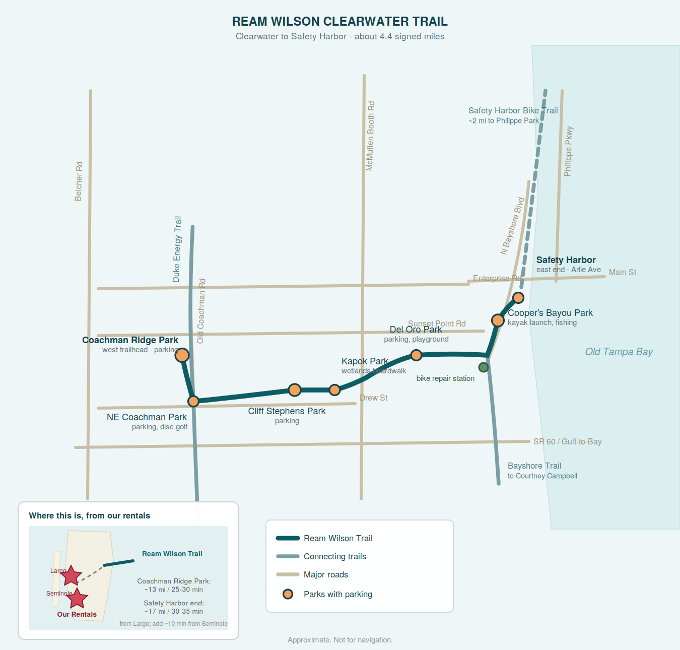
The Route
West to east, with rough distances:
- Coachman Ridge Park (parking, picnic, playground, sports facilities). The trail starts roadside along Old Coachman Road.
- Across NE Coachman Road and a railroad track, where it merges with the Duke Energy Trail and the two run together past Northeast Coachman Park (parking, picnic, disc golf).
- Through Cliff Stephens Park — about 1.5 miles from the start. Parking here too.
- On to the McMullen Booth bridge, roughly another mile. Kapok Park sits nearby with a wetlands boardwalk and native wildlife worth the short detour.
- Across the bridge to Del Oro Park (parking, picnic, playground, tennis, basketball), then through a pleasant residential stretch.
- At N. Bayshore Blvd, about 0.6 miles further, the trail splits: Ream Wilson goes left (north), and the Bayshore Trail goes right (south) toward the Courtney Campbell Causeway.
- North about a quarter mile to Cooper’s Bayou Park — parking, walking paths, fishing, a kayak and canoe launch, and a fitness course.
- Roadside with one crossing to Arlie Avenue at the Clearwater–Safety Harbor city limits, about 0.8 miles on. From here a connection over a canal picks up the Safety Harbor Bike Trail (also called the Bayshore Linear Greenway), running roughly two more miles to Philippe Park.
Where to Park
🥇 Coachman Ridge Park — West Trailhead
1400 Old Coachman Rd, Clearwater. Parking, picnic areas, playground, sports facilities. Start here for the full trail with the Safety Harbor payoff at the far end.
🥈 Cliff Stephens Park
901 Fairwood Ave, Clearwater. Parking, and a good midpoint if you want a shorter out-and-back in either direction.
🥉 Cooper’s Bayou Park — Closest to Safety Harbor
709 N Bayshore Blvd, Clearwater. Parking, fishing, kayak launch. Park here if the plan is lunch in Safety Harbor and a short ride rather than the reverse.
Also
Northeast Coachman Park (1120 Old Coachman Rd), Del Oro Park, the Long Center, the Eddie C. Moore Recreation Complex, and Veterans Memorial Lane at the Safety Harbor end.
Two Ways to Ride It
🍽️ The Safety Harbor Lunch Ride — ~9 miles round trip
Start at Coachman Ridge Park, ride the full trail east, eat in Safety Harbor, ride back. Under ten miles total with shade for most of it, which makes this one of the few rides in our guide that works comfortably in warm weather.
What you’ll pass: the disc golf course at Northeast Coachman Park, the Kapok Park wetlands boardwalk, the McMullen Booth bridge crossing, and the water views along N. Bayshore Blvd on the approach to Safety Harbor.
Where to eat in Safety Harbor — downtown is compact and almost entirely independent:
- The Tides Market, 305 Main St — seafood market and restaurant in one, with a shaded patio and daily happy hour from 4–7 including dollar oysters. Our pick.
- Gigglewaters, 737 Main St — Prohibition-themed bar and restaurant with a 32-seat movie theater in the back and a patio under a big tree. Genuinely unusual.
- The Brinehouse, 100 Main St — barbecue and sandwiches, live music some evenings. Closed Mondays.
- Water Oak, 201 Main St — a step up in price; seafood and steak.
- Whistle Stop Grill and Bar, 915 Main St — the long-running local hangout, American food, frequent live music.
Coffee and breakfast: HavenHouse Local Eatery (201 Main St, upstairs with a balcony over Main Street, closed Sundays), Café Vino Tinto (509 Main St, walk-up window and a shaded patio, closed Mondays), or Good Day Cafe (310 Main St — tiny, excellent, and only open Wednesday through Sunday until 2pm).
🌿 The Parks Loop — ~4 miles round trip
A branch of the trail heads west off N. Bayshore Blvd through a series of linear parks. A loop out to Del Oro and Kapok Park and back is about four miles, and the shade and boardwalk make it the most pleasant short ride in the area. Good with kids, good in summer, good if you just want an hour outside.
Know Before You Go
🔧 There Are Bike Repair Stations
Unusual and worth knowing: there are fix-it stations near Bayshore Boulevard, in the Long Center parking lot, and near the Eddie C. Moore softball complex. Drinking fountains and restrooms are frequent along the route too — this is a well-appointed trail by Florida standards.
🚦 Street Sections
Parts of the trail run roadside rather than through parkland, with road crossings to navigate. It’s well signed, but this isn’t a fully separated corridor end to end.
🚶 It’s Busy
Walkers, runners, cyclists, skaters, and commuters all use it, and it doubles as a transportation route rather than purely a recreational one. Ride accordingly.
☀️ Still Florida
Better shaded than most trails around here, but “mostly shaded” isn’t “fully shaded.” Start early and carry water in summer regardless.
Beyond the East End: Philippe Park
If you have the legs, keep going. The Safety Harbor Bike Trail continues roughly two miles from the city limits to Philippe Park (2525 Philippe Parkway) — a waterfront county park on Tampa Bay with picnic areas, big oaks, and a Native American temple mound. It’s one of the oldest parks in the county and a genuinely good place to end a ride.
Connecting Trails
- Duke Energy Trail — overlaps at Northeast Coachman Park; north to the Pinellas Trail, south to Belleair Road
- Bayshore Trail — branches south at N. Bayshore Blvd toward the Courtney Campbell Causeway
- Safety Harbor Bike Trail — continues east from Arlie Ave to Philippe Park
- Pinellas Trail — reachable via the Duke Energy Trail
👉 Our Duke Energy Trail guide | Our Courtney Campbell guide | Back to our biking guide
Getting There from Our Vacation Rental
From: 1731 Clearwater Harbor Dr, Largo, FL
To Coachman Ridge Park (west trailhead): roughly 13 miles, 25–30 minutes.
To Cooper’s Bayou Park (Safety Harbor end): roughly 17 miles, 30–35 minutes.
📱 GPS directions to Coachman Ridge Park
If you only have one morning and you want shade, a boardwalk, and lunch somewhere good at the end of it — this is the ride we’d point you at.